
For Planning director · Departmental records owner · Agency service leader · Senior technical architect
Many public bodies hold valuable information in forms that are difficult to reuse. It sits in scanned plans, typed schedules, microfiche, folders of correspondence and decades of decisions recorded in whatever format was current at the time. Officers know it is there, and they consult it one document at a time, but no system can query it, join it to anything else or publish it. Two well-documented examples of AI applied to that problem in England come from planning and land registration: the Ministry of Housing, Communities and Local Government's Extract tool, built with the Incubator for Artificial Intelligence (i.AI), and the AI-assisted migration of local land charges records run by HM Land Registry.
Both programmes have published unusually candid accounts of what they built, and both report large reductions in the effort needed to digitise records. This article reads those accounts closely. It asks what problem each organisation was solving, what it actually implemented, what the published figures demonstrate and what they leave open. It then considers the question that matters most to anyone responsible for a register, a casework system or a records collection, which is when extracted information becomes something an organisation can responsibly treat as its record. Inference Public had no part in either programme, and everything reported here comes from the organisations' own publications.
Three kinds of document work
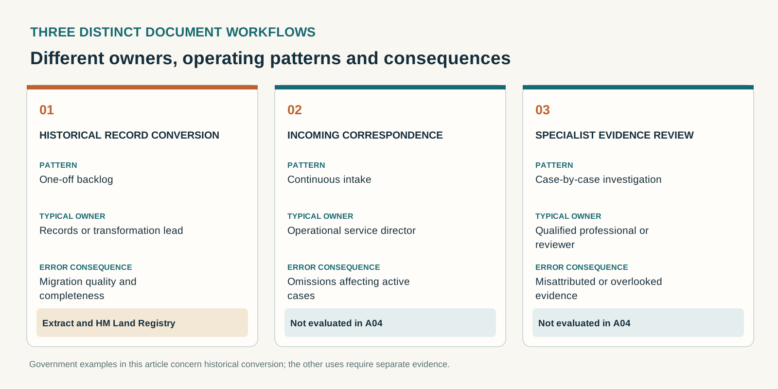
It helps to separate three operational contexts that are often discussed as one, because they have different owners, budgets and consequences.
The first is historical record conversion: taking an archive that already exists and turning it into structured data, usually once, often to feed a new system or a national dataset. The work has a defined end, a backlog that can be measured and a sponsor who is typically a programme or a transformation budget. Both programmes discussed here sit firmly in this category.
The second is ongoing correspondence processing: documents that arrive every day, such as applications, notices, letters and supporting evidence, whose contents need to be captured into a live case or record. This is operational work owned by a service, funded from running costs and judged on throughput and service standards. Errors here affect individual cases while they are still open.
The third is specialist evidence review: assembling and examining bundles of material for a decision with legal or professional weight, such as a tribunal, an appeal, a safeguarding review or an enforcement case. Volumes are lower, each document matters more, and the reviewer is usually a qualified professional whose judgement is the point of the exercise.
The evidence that government has published so far is concentrated in the first category. That is worth keeping in mind, because results achieved converting a bounded archive under programme conditions do not automatically transfer to a daily operational flow or to evidence that will be tested in a hearing.
The problems being solved
Planning constraints locked in old documents
The data Extract targets describes constraints on land: where conservation areas run, which properties are covered by Article 4 Directions removing permitted development rights, and which trees are protected by Tree Preservation Orders. MHCLG's alpha write-up describes this information as trapped in paper maps, scanned PDFs and legacy microfiche, and puts the time for a trained officer to convert one document by hand at one to two hours. The government's June 2026 announcement estimated that planning officers spend around 250,000 hours a year manually checking such documents.
The difficulty is partly that the documents combine text and maps. The alpha team reported that standard language models handle the words well but cannot natively read a map or produce a precise boundary, and described georeferencing, the step that places a hand-drawn boundary accurately on a modern map, as its biggest hurdle. A boundary has to be traced from an old drawing, matched to features that still exist, such as road junctions and building corners, and fitted to real-world coordinates. Optical character recognition alone recovers none of that, and manual conversion requires skilled GIS work for every document.
A statutory register moving to a national service
The local land charges problem is different in kind. Local land charges are mostly restrictions or prohibitions on the use of property, such as conditional planning permissions, listed building status and conservation areas, and they are revealed to buyers through searches. Under the Infrastructure Act 2015, HM Land Registry is taking over the 331 local land charges registers across England and Wales through a phased programme, becoming the registering authority for each area once it migrates. The programme's live directory lists authorities with their transfer dates, some still in the future, and is the place to check the current position.
Before an authority's records can move, HM Land Registry's account explains, every line has to be reviewed, checked for accuracy and digitised, from records held in electronic, paper and other formats. The post describes this as work that has needed large teams and months of effort. Its author also notes that earlier versions of the tooling required bespoke code for each authority and ran on physical workstations, which is a reminder that the real obstacle lay in the many ways 331 authorities had kept their registers over decades.
What each programme implemented and reported
Extract
The alpha phase, described by MHCLG and i.AI in June 2025, split the task into a text pipeline and a map pipeline. Language models read the document and returned dates, locations and decisions in the structure required by the Digital Planning platform's data schemas, using constrained "structured outputs" so that every result followed the content model. Vision models were combined with OpenCV and Meta's Segment Anything Model to trace boundaries, and an automated georeferencing step located ground control points against Ordnance Survey mapping to place each polygon. The team described its method as evaluation-driven development: it assembled a set of real planning documents from across the country paired with modern equivalents, and measured every model and code change against that set.
On that evaluation set, the alpha reported that all expected text fields were extracted, 94% of dates were correct, 90% of traced boundaries reached an intersection over union of 0.8 or more against human-drawn ground truth, and 82% of boundary centres fell within 10% of the true shape's diameter. It put the cost at about 10p and under three minutes per document. The government's June 2025 press release said Extract was being developed and expanded with Google using its Gemini model, so Extract's approach is supported by Google technology.
By April 2026 the programme had moved to structured testing with planning authorities. That update reported no new accuracy figures, said officers would review and confirm outputs before data was used, and recorded that accessibility, privacy and security approvals were complete while the service was prepared to run on MHCLG's systems.
Extract went live for every local planning authority in England on 17 June 2026, free of charge, supporting three document types: conservation areas, Article 4 Directions and Tree Preservation Orders. The launch post reported that 34 authorities had taken part in research and testing, that 50 were actively using the tool, that more than 1,000 documents had been processed in the first few weeks, and that around two thirds needed only minor edits before the data was ready. It said officers can spend up to two hours digitising a record by hand, which Extract can do in two minutes for some document types, and that planning and GIS officers review, correct and then export everything the tool produces. Outputs can be exported to an authority's own systems and to the national Planning Data Platform. A reply from the team in November 2026 said a closed pilot covering Section 106 agreements and planning conditions would run over the following weeks.
Local land charges
HM Land Registry's March 2026 post describes a tool that combines an enhanced optical character recognition engine, a large language model and several bespoke models to identify, extract and structure local land charges information. It describes controls that prevent common transcription errors, such as reading the letter O as zero, and strict controls intended to stop the system generating false information or importing non-data content such as website menus. It runs in HM Land Registry's secure cloud infrastructure; the post names neither the provider nor the model.
The headline result concerns Newham, the first authority whose textual charges information was processed this way and passed all data quality checks. HM Land Registry had estimated that capturing Newham's data would take 20 colleagues three months; the post reports that the task was completed in four weeks with four people, and that every batch passed data quality assessment first time. One team member processes the data, after which a separate data quality and assurance team cross-checks the output, and the post reports no quality or completeness failures to date. The post does not describe how that cross-check samples or covers individual records. The tool has also been used for Dacorum and Cotswold, and HM Land Registry plans further work on handwritten and poorly scanned records, which it describes as challenging.
What the results demonstrate, and what they leave open
Read together, these accounts establish something useful. Both teams report improvements in the effort or speed of historical record conversion, supported by human quality controls, and both have moved from prototype to repeated use. Extract expressly requires officers to review and correct every output before export, while HM Land Registry reports a separate quality and assurance stage and successful batch assessments; the published accounts do not establish equivalent per-record review methods or escaped-error rates. For a records owner wondering whether the approach is viable at all, the reports are still meaningful evidence. They show promising reductions in machine processing time and in the staff effort reported for a specific migration, although they do not give a comparable end-to-end measure of fully reviewed, accepted records across the two programmes.
It is equally important to be precise about what kind of evidence it is. The figures examined here come from the programme teams' published accounts. MHCLG also links to a fuller evaluation by i.AI, which worked on Extract's development, but that report was not available for inspection during this review. We therefore make no claims about evidence it may contain, and we have not established a separate external evaluation of the outcomes of either programme. The alpha accuracy figures were measured on the team's own evaluation set before the service was hardened for live use, and the launch post does not report accuracy against ground truth in live use; it reports edit rates instead. "Around two thirds needed only minor edits" tells us how much work officers did, and implies that around a third needed more than minor correction, but the post gives no breakdown of how much correction the remaining third needed, and it does not tell us how many errors officers did not notice.
The time comparisons need similar care. Two minutes is the time the tool takes to produce an output for some document types, and two hours is the upper end of manual effort; the comparison does not include the time officers spend reviewing and correcting, which is the work that makes the output usable. The government's June 2026 press release projected that an average council would save around 255 hours of manual work, down from more than 500, and gave no method for that projection. These are reasonable planning estimates, but they are estimates of effort, made before a full year of live use.
HM Land Registry's Newham comparison is more concrete, since it compares an actual outcome with the programme's own prior estimate, but it remains a single authority measured against a forecast and was not set up as a controlled comparison. "Every batch passed data quality assessment first time" is a strong statement about the checks HM Land Registry runs, and the report of no failures to date is a statement about failures found so far; neither is a measured error rate, and the post does not describe what the checks test for. A format and completeness check and a check that each charge has been transcribed faithfully from the right source are different tests.
What remains unproven, across both programmes, is the thing a service leader most needs to know before relying on the data: the rate and kind of errors that survive review and enter the record, and what they cost when they are found. Almost no document AI deployment publishes that measurement, so its absence here reflects the state of the field as much as either team's choices, and the reason it matters becomes clear once we look at what happens to extracted data after it is accepted.
Figure 2. Published results describe selected accuracy and effort measures; they do not establish end-to-end accepted-record cost or escaped-error rates.
| Published finding | What it measures | What it does not measure |
|---|---|---|
| Extract: two thirds minor edits | Officer correction effort during early use | Escaped errors or severity of other cases |
| Extract: some documents 2 minutes vs up to 2 hours | Tool output time versus manual effort | Total time including review |
| Extract alpha: 94% dates and 90% boundaries at IoU ≥0.8 | Alpha evaluation-set results | Accuracy on later live deployments |
| Newham: four people four weeks versus earlier estimate of 20 people three months | Reported effort against a forecast | Controlled comparison or escaped errors |
From extracted value to accepted record
Turning a document into structured data and creating a record that an organisation can rely on are different achievements. Three separate questions sit between them, and each can be answered by a different person.
Fidelity asks whether the data says what the source says. A transcribed date, a reference number or a traced boundary is either faithful to the document or it is not, and the errors take three forms that behave differently. A value can be wrong, it can be attributed to the wrong place in the document, or it can be missing because the system never extracted it. Omissions are the hardest to catch, because a reviewer checking what the system produced sees nothing to correct. The alpha team's decision to score text fields, dates, boundary shapes and boundary positions separately is a good model, since each measures a different way of being wrong.
Source authority asks whether the document is the right one to rely on. A Tree Preservation Order may have been varied or revoked; a conservation area may have been extended; a register entry may have been superseded by a later instrument that sits in a different file. A perfectly faithful extraction from a superseded document produces a confident, wrong record. Establishing authority usually requires knowledge of the legal and administrative history that the document itself does not contain, and it belongs to someone who understands that history.
Fitness for use asks whether the data is good enough for what it will now be used to decide. A coarse representation may be adequate for an explicitly indicative analysis of an area and wholly inadequate for deciding whether a particular property falls within a legally significant boundary. Fitness for use must therefore be judged against the stated purpose, the source's legal status and the tolerance that use permits, which is why acceptance has to be recorded against a stated purpose by someone accountable for it.
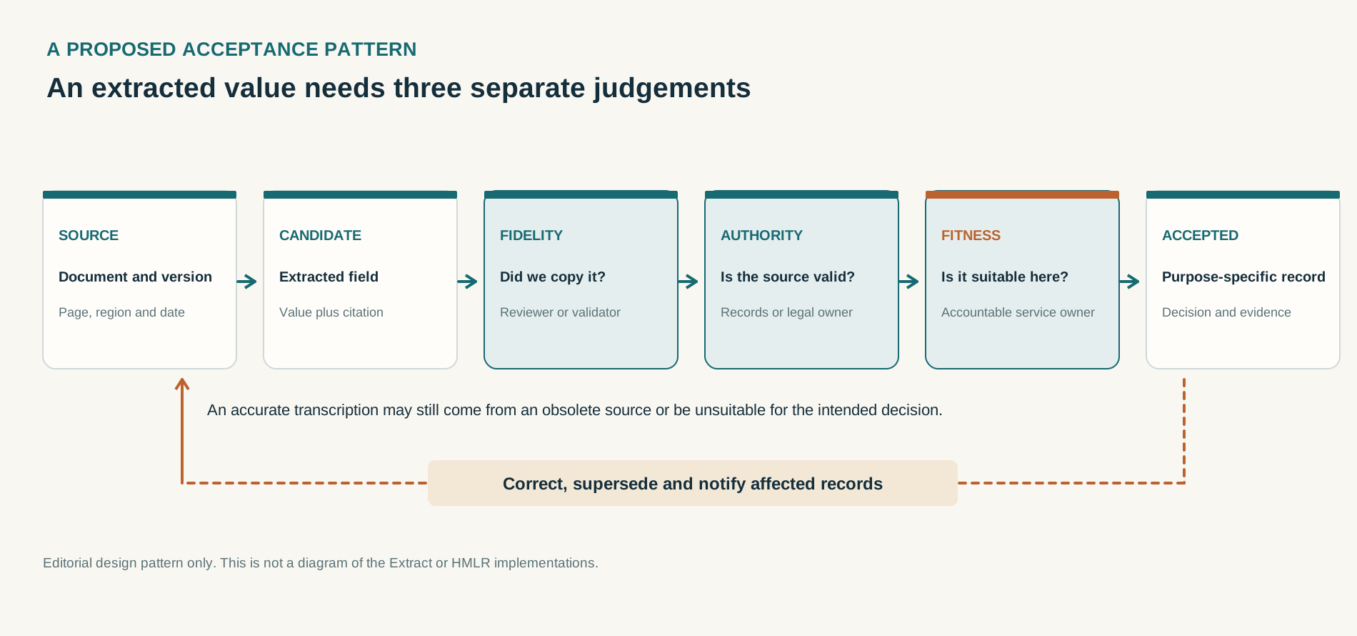
These distinctions matter because accepted data travels. Extract's outputs can be exported into the national Planning Data Platform, where they inform other systems and the public. Once local land charges data has entered the national register, it may inform searches on which purchasers rely. Under section 10 of the Local Land Charges Act 1975, a purchaser may be entitled to compensation where a qualifying search fails to reveal an existing charge and the statutory conditions for consequential loss are satisfied. HM Land Registry's compensation protocol also identifies circumstances in which compensation it pays may be recovered from a local or originating authority. A migration error that escapes into the register can therefore create legal and financial exposure, although whether liability arises, and where it falls, depends on the facts and the relevant statutory provisions. A missed or misplaced protection in a planning constraints layer carries a comparable risk, since it can lead a developer, an officer or a resident to act as though a protection does not exist.
Two practical consequences follow. First, review needs to be designed around the errors that matter, which means expected-field checks for omissions, reference to the source location for every value, and explicit handling of conflicting or superseded documents, as well as a reviewer looking over each output. Second, an organisation needs a way to trace an error found after acceptance back to the records that share its cause, because an error in one migrated batch rarely occurs only once.
What this teaches about engineering document intelligence on AWS
Neither programme is described by its owners as running on AWS, and Extract's own publications point to Google's models. The engineering lessons apply on any platform, and public bodies that build on AWS will meet them in a particular form, and it is worth setting out how. What follows is Inference Public's proposed engineering approach. It describes neither government programme, and no single AWS product provides it as a ready-made feature set. A forthcoming companion article on extracting records from documents on AWS covers architecture and evaluation in depth.
The managed services help most with the parts of the problem that are now well understood. Amazon Textract provides optical character recognition and the extraction of forms, tables and queried fields, with a London endpoint, which suits typed and structured documents where layout carries meaning. Amazon Bedrock Data Automation applies configurable blueprints to classify documents and return fields to a defined schema, and its London geographic profile currently restricts processing for London-originating requests to the London region, although the profile, model and policies actually selected need to be checked against that documentation. Foundation models available through Amazon Bedrock add the ability to read irregular text, reason about a document's structure and return output constrained to a schema, which is close to the approach Extract's alpha took for text. Each of these needs to be checked for availability in the region and processing route the service requires on the day of design, because model availability and cross-region inference behaviour change.
None of them decides what the record should contain, which document is authoritative or when a value is good enough to accept, and none of them measures its own error rate on your documents. Those responsibilities stay with the public body. It owns the data schema and the rules for each field, the reference set of documents with known correct answers against which any system is measured, the decision rules for conflicting or superseded sources, the identity and permissions of reviewers, and the acceptance record itself. It also owns the security decisions that frame everything else: encryption keys, network boundaries, retention, and whether any processing may leave the UK.
Review tooling deserves particular attention. Amazon Augmented AI and SageMaker Ground Truth, the managed services AWS has offered for human review and labelling, closed to new customers on 30 July 2026, although existing customers can continue to use them. A new implementation therefore needs a review queue that lives elsewhere, usually in the case management or records platform the organisation already operates, or in a purpose-built application. That is less of a constraint than it sounds, since the review step is where the acceptance decision and its evidence must be recorded, and that record is best kept with the operational system it governs.
An implementation partner's job sits between those two layers. It includes building and maintaining the reference set and the measurement that runs against it, capturing for every extracted value the source document, page and region it came from and the configuration that produced it, designing review around omissions and authority as well as obvious errors, integrating acceptance into the system of record, and leaving the service in a state the organisation's own team can operate. It also includes the unglamorous work of quotas, retries, monitoring, cost controls and failure handling, since a pipeline that silently drops a page produces exactly the omission that review is least likely to catch.
The measure that ties these together is the cost of an accepted record. Per-page processing prices are small and easy to compare, and they are rarely what determines whether a programme saves money. The observed cost of an accepted record includes processing, reviewer time, rework and the handling of documents the system cannot process, and it can be measured directly on the organisation's own documents. A design that cuts extraction cost while adding a minute of review to every record can be the more expensive one. The harm from errors that escape into the record belongs in the same assessment, but it has to be reported separately, as measured escape frequencies and consequences together with expected-loss scenarios whose assumptions are written down, since folding an estimate into a measured unit cost makes it look more certain than it is.
Before commissioning another implementation
The first question for any public body is whether it needs to build anything. Extract is free to every local planning authority in England for the document types it supports, and it exports to the national data platform. HM Land Registry's local land charges programme already provides a route for authorities to migrate their registers. Where a national service meets the need, using it avoids duplicated cost and aligns the authority's data with national standards, and the most useful local work may be preparing documents, resolving authority questions and assuring the results. The cross-government NDX:Try service also lets councils explore AWS-hosted document scenarios before buying anything, which is a reasonable way to test an idea, although its demonstrations are not designed to measure accuracy on a council's own records.
Where a national service does not fit, because the document family is different, the work is ongoing correspondence rather than a one-off backlog, or the evidence will be used in specialist review, a service owner should be able to answer a short set of questions before commissioning.
- Which document family, in what volume, and for which record? Name the documents, the backlog or monthly flow, and the system the data will enter.
- Who accepts the data, for what purpose, and how is that decision recorded? Acceptance should name an accountable role and a stated use.
- How will fidelity be measured? There should be a reference set from your own documents, with omissions and misattributions reported separately from wrong values.
- How will source authority be established? Decide who resolves superseded, varied or conflicting documents, and what the system does when authority is unclear.
- What does an error that survives review cost, and who bears it? Consider the legal, financial and service consequences, and how an error found later will be traced and corrected across affected records.
- What will an accepted record really cost? Include review, rework, exceptions and escaped errors as well as processing.
- Who will operate and own the service afterwards? Name the team, the skills and the budget beyond the project.
The answers differ sharply across the three contexts. A historical conversion can tolerate a longer review per record, because the work is bounded and the reference set can be built from the backlog itself. Ongoing correspondence needs review that keeps pace with a service standard, which puts pressure on exception handling and staffing. Specialist evidence review needs the strongest provenance of all, since every extracted statement may be challenged and has to be traceable to its source.
How we approach this work
Inference Public's engineering approach to document intelligence on AWS begins by establishing whether an existing national service meets the need, what the resulting record is for and how its quality would be measured. Where bespoke work is justified, the design must cover provenance, field-level evaluation, proportionate review, acceptance and correction alongside extraction. This is the method we are developing, and nothing in this article suggests that we delivered either programme discussed above.
Related reading
RAG Is a Data Product: Building Trustworthy Retrieval on AWS, on retrieval once documents and records have been accepted
Sources
- MHCLG Digital, "Extract: Using AI to unlock historic planning data", 12 June 2025
- Prime Minister's Office and MHCLG, "PM unveils AI breakthrough to slash planning delays and help build 1.5 million homes", 9 June 2025
- MHCLG Digital, "Extract: unlocking England's planning data", 15 April 2026
- MHCLG Digital, "Extract is here: AI-powered planning data for every council in England", 17 June 2026
- MHCLG, "AI tool to slash planning decision times as government accelerates push to build 1.5 million homes", 16 June 2026 (text dated 17 June)
- HM Land Registry, "Transforming local land charges migrations with AI", 17 March 2026
- HM Land Registry, "Local Land Charges Programme", updated 17 November 2026
- Local Land Charges Act 1975, section 10
- HM Land Registry, Practice guide 79: Local Land Charges, updated 19 October 2026
- HM Land Registry, Local land charges compensation protocol, updated 21 April 2021